49. Cabecera noticia SIGAUS y ESRI
SIGAUS and ESRI, partners in fostering the circular economy through geospatial technology
SIGAUS uses Esri’s geospatial technology to monitor waste oil management in Spain through the development of a digital observatory. In addition to the traceability of waste oil throughout Spain, the organisation has prepared a study on the management of used oil as an indicator of local development for the municipalities of the Guadarrama National Park.
 25-04-2024
24. Parrafo noticia SIGAUS y ESRI
In its commitment to putting innovation at the service of sustainability, SIGAUS (the system ensuring proper management and promoting the Circular Economy in the area of industrial waste oils) has entrusted Esri Spain, a worldwide leader in geospatial technology, and its partner, Estudios GIS, to take a qualitative leap in terms of information systems and waste traceability.
A partnership of over 10 years that allows us to address the challenge of geolocating every litre of waste oil generated in any corner of the country and to make the best decisions in the face of any unforeseen event. It is estimated that one litre of industrial waste oil can contaminate one million litres of water, and in Spain about 160,000 tonnes of this waste are generated annually in more than 70,000 points distributed throughout the country.
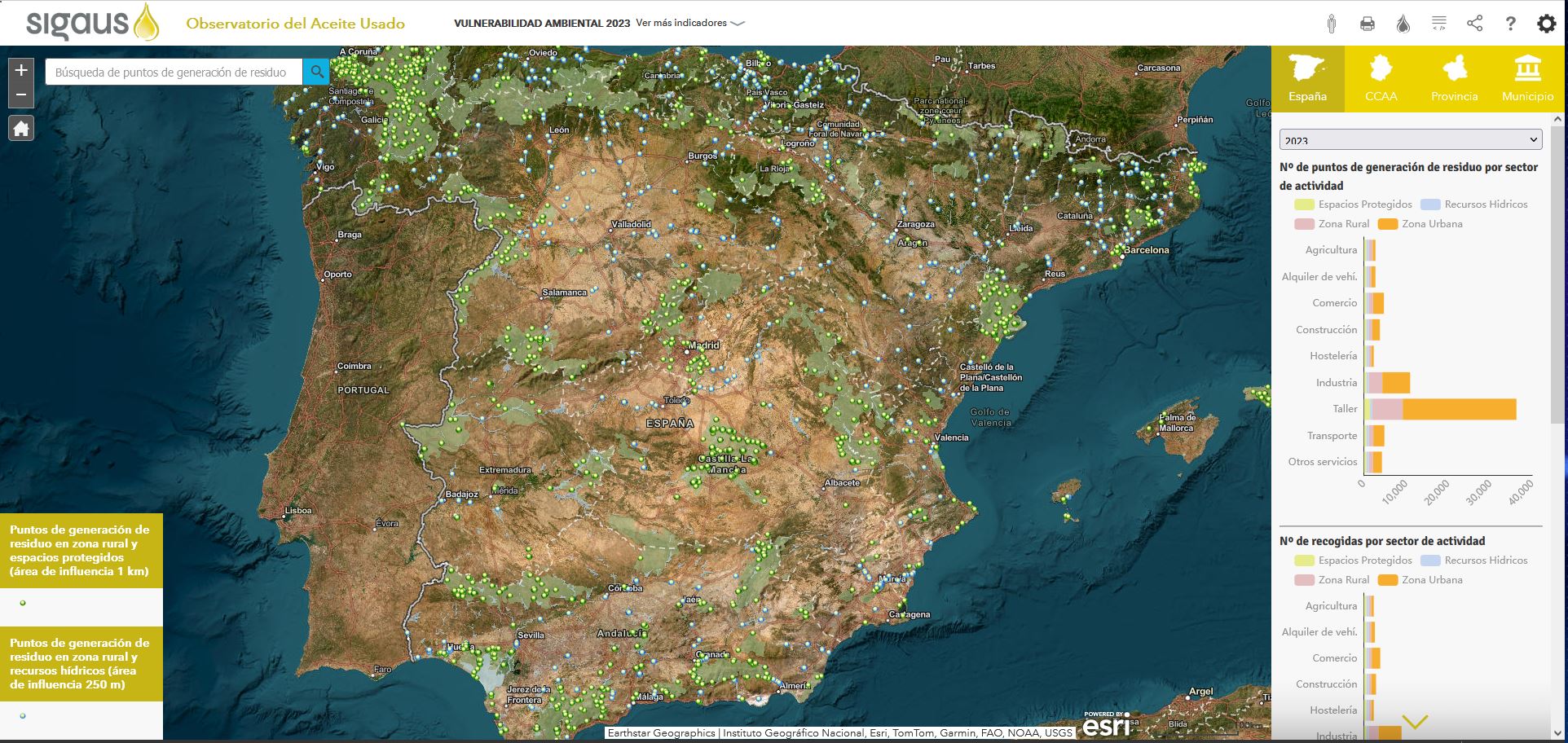
Through this collaboration, SIGAUS has developed the Industrial Waste Oil Observatory portal using the ArcGIS Online system. This joint effort significantly improves the capacity to monitor and visualise waste oil generation points, setting a unique standard in the environmental management of industrial waste.
Understanding and improving environmental management
Incorporating the latest geospatial technology in SIGAUS' information systems has marked a turning point in our ability to understand how this waste is generated and managed at each point in the territory, offering the possibility of creating interactive maps and ad hoc graphic representations.
32. Parrafo cita noticia SIGAUS y ESRI
“
The Waste Oil Observatory is an example of how GIS systems improve waste control and management, being more effective in conserving natural resources.
„
This makes it possible to optimise management and visualise the importance of a system ensuring the universality of the service, including capillary collection in rural, mountainous areas and/or areas far from large population centres and economic activity. The platform displays waste movement between generation points and management facilities, as well as providing information on the benefits derived from waste oil management, such as energy savings and avoided CO2 emissions, making it a value-added tool for assessing the positive impact of the performed environmental management.
From a technical standpoint, the solution is highly flexible and can be adapted and scaled according to need: the public interface facilitates visualisation of large magnitudes, while the private interface offers additional variables and advanced geographic analysis tools.
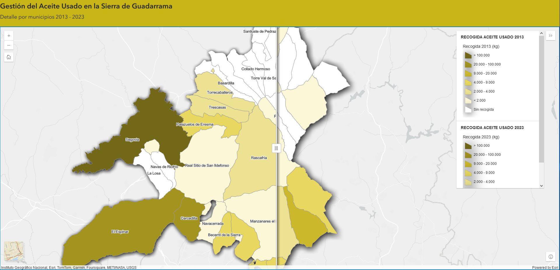
GIS applied to a specific case: Guadarrama National Park
To mark the 10th anniversary of the 2013 declaration of this National Park, SIGAUS used this solution to study the evolution of waste oil management in the municipalities of the emblematic Park, creating a specific application to visualise data from this area of great environmental importance. This analysis offers a unique opportunity to assess how the declaration of the National Park has contributed to local development, and how, in turn, waste oil management can also serve as an indicator linked to the evolution of this economic activity.
24. Parrafo noticia SIGAUS y ESRI (II)
Geospatial technology at the service of the circular economy
At a time when the circular economy is emerging as a clear goal for governments and multiple economic sectors, the development of the SIGAUS Industrial Waste Oil Observatory highlights the paradigmatic example of how GIS systems can become drivers of change, improving waste control and management, becoming more effective in conserving natural resources.
In the words of Eduardo de Lecea, general director of SIGAUS, “We already had a huge database for the management of waste oil in Spain. More than 160,000 transactions per year that we register and automate. By adding a geographical context and being able to locate each movement in the territory, we can increase our capacity for control and management. The data becomes more accessible and articulate. We can take more informed decisions and we also benefit when it comes to communicating the work we do in a more visual and attractive way.”
25. Galeria noticia SIGAUS y ESRI
Image gallery